
The $39-million Lower Owens River Project (LORP) begun in 2006 is a sixty-two-mile long river restoration project covering 77,657 acres in the Owens Valley. The project is the largest of its kind ever attempted in the United States. The goal of this legally mandated project is to rewater the formally dry Owens River channel and the adjacent floodplain that had been drained after the City of Los Angeles diverted the natural course of the river into the newly constructed Los Angeles Aqueduct in 1913.
The LORP is one of the mitigation projects outlined in the 1991 Inyo-LA Long Term Water Agreement (LTWA) and was legally required by the 1997 Memorandum of Understanding (MOU) between the City of Los Angeles, Inyo County, LADWP, the California Department of Fish and Game, the State Lands Commission, the Sierra Club, and the Owens Valley Committee (OVC). The LORP is a legally binding compensation meant to offset ecological damage caused by excessive groundwater pumping instigated by LADWP from 1970-1990. After years of political bickering during a drawn-out series of lawsuits brought on by various entities, the LORP was officially launched on December 6th, 2006 bringing water to the dry river bed which had been waterless for ninety-three years.[1]
“The goal of the LORP is the establishment of a healthy, functioning Lower Owens riverine-riparian ecosystem, and the establishment of healthy, functioning ecosystems in the other physical features of the LORP, for the benefit of biodiversity and Threatened and Endangered Species, while providing for the continuation of sustainable uses including recreation, livestock grazing, agriculture, and other activities.”[2]
The 1997 MOU required that the LADWP establish “a permanent base flow of forty CFS in the river channel and higher seasonal habitat flows” for two waterfowl and shorebird riparian habitat areas including the 20,400-acre Blackrock Waterfowl Management Area and the Owens River Delta Habitat Area plus several off-river lakes and ponds.[3] Water received at the Owens Lake Delta located at the north end of the lake is used for a separate federally mandated air pollution mitigation project managed by LADWP to control dust storms on the dry lakebed. Any excess water not used at the lake is pumped back into the Los Angeles Aqueduct at a pumping station located at the delta.
The LORP has been successful in enhancing the fishery, creating riparian and marsh habitat, and promoting recreational opportunities such as fishing and canoeing. In 2011, the Los Angeles Times reported that “there are 4,000 largemouth bass and 2,000 bluegills per mile, and 108 species of birds, forty-one of them new to the area.”[4]
There have been obstacles, however, including the management of non-native resident beavers who enjoy dining on young willow and cottonwood seedlings that, in turn, fail to establish. The establishment of deciduous riparian habitat is necessary for a complete restoration. The LADWP biologists overseeing the LORP are working on ways to either control or eliminate the beaver. Free-range cattle present their own management issues as grazing cows contaminate and trample delicate stream vegetation. Tules (a species of native California bulrushes and other similar vegetation) along with other non-natives such as salt cedar, also wreak havoc with the preferred habitat model. Overgrown tules and salt cedar obstruct ideal stream flows and strangle the river if allowed to dominate the riparian corridor and channels.
Blackrock Spring Controversy
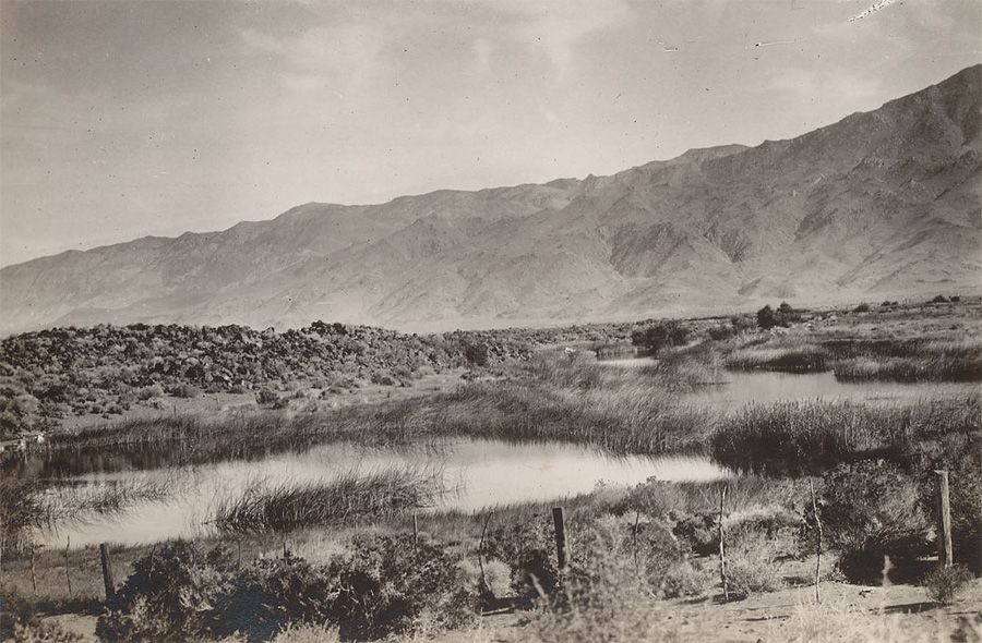
Mary DeDecker, founder of the Bristlecone Chapter of the California Native Plant Society (CNPS) singled out the naturally flowing Little Black Rock Spring as, “a prime habitat, a center of life where unusual species flourished and the aesthetic beauty was superb.”[5]
Located about twelve miles north of Independence, the original spring flowed at about 8,000-acre feet per year (a.f./yr) and once supported a rich and diverse ecosystem of alkali marsh and meadow, saltbush scrub, and various mountain species including Intermountain Bird’s Beak (Cordylanthus ramosous). In 1941, the Department of Fish and Game (DFG) established a fish hatchery just south of the Blackrock site and diverted water from the spring for hatchery operations. Still in operation, after servicing the hatchery water flows directly into the Los Angeles Aqueduct.
Beginning in the early 1970s, LADWP increased pumping in the Blackrock area to fill its newly constructed second aqueduct. Consequently, the Little Black Rock Spring diminished and stopped flowing entirely thus destroying the fragile meadow ecosystem it had previously supported.
To compensate for the loss of spring flow to the hatchery, the LADWP sited two wells nearby to provide replacement water. These wells are exempted from the LTWA. In addition, LADWP increased pumping at these wells from 8,000 a.f./yr to 13,000 a.f./yr., which is nearly double the spring’s natural flow.[6] As the water table dropped further from pumping, the remaining native groundwater-dependent alkali meadow died off and has led to desertification.[7]
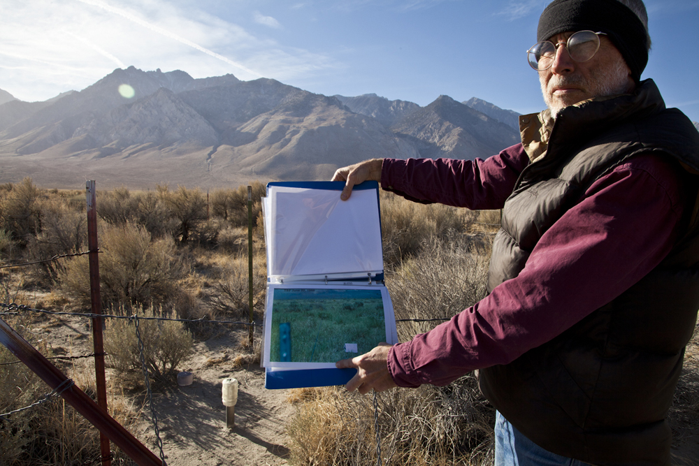
Bristlecone Chapter CNPS botanist, Daniel Pritchett has been conducting environmental monitoring at multiple Blackrock sites since 1987 (as required by the LTWA). His findings show drastic changes between two specific sites; one supported with adequate groundwater and one without—even to the untrained eye the visual difference in habitat quality at these two sites is staggering.
Due to the ongoing ecological degradation at Blackrock, the OVC and the Big Pine Paiute Tribe became involved in a legal effort to curtail the excessive pumping. Their lawsuit against the Department of Fish and Game (DFG), which operates the hatchery and is consequently responsible for the degradation, demanded that they work with LADWP to reduce groundwater pumping in the Blackrock area to the average historic spring flow rate of 8,000 a.f./yr—the amount deemed necessary to sustain the rare meadow habitat but also provide enough water to operate the fish hatchery.[8] A settlement was reached in December 2011.
Besides the Blackrock Fish Hatchery, there are two other hatcheries in Owens Valley; the historic Mt. Whitney Hatchery (closed) near Independence and the Fish Springs Hatchery, just south of Big Pine. Statewide, sports fishing brings in $3 billion in revenue annually.
POI: Blackrock Springs Hatchery
Visitors are welcome to visit the fish hatchery during regular business hours. Exit east onto Colosseum Road aka Blackrock Springs Road. The hatchery is approximately one mile north of the exit and 6.5 miles north of Independence.
Latitude: 36.928149°
Longitude: -118.232033°
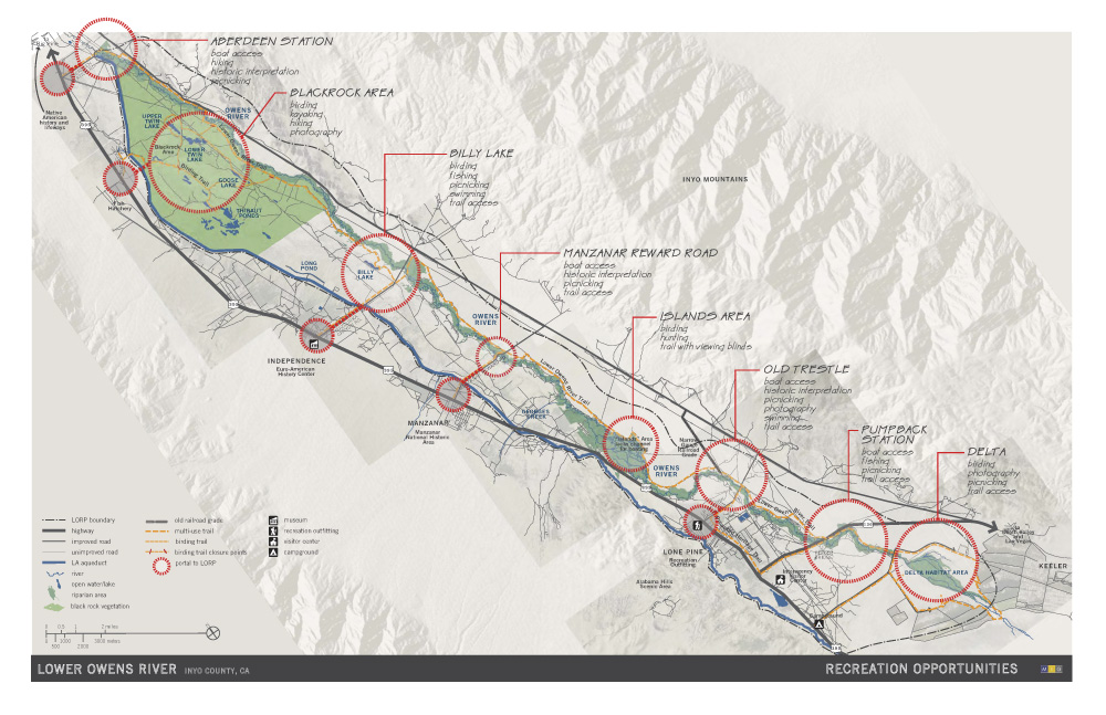
POI: Lower Owens River Project
There are various LORP recreational areas and wildlife viewing areas located throughout Owens Valley. For a LORP recreational map visit Inyo County Water Department’s LORP webpage.
Track Credits
Special thanks to NPR affiliate, Carrie Kahn for providing the Antonio Villaraigosa recording at the opening of this track. Listen to Kahn’s original NPR Morning Addition broadcast from December 7, 2006; “L.A. Returns Water to the Owens Valley”. Music: Black Twig Pickers and Steve Gunn, “Salted Caramel” (Creative Commons license).
FOOTNOTES (click to open/close)
[1] Initial LORP restoration was delayed twice by LADWP until an Inyo County Superior Court Judge ordered in 2005 that the city of Los Angeles was required to commence flows to the river by 2007 or their water exports through the second aqueduct would be stopped altogether. The city was fined $5000 a day until the compliance was met.
[2] Quoted from the 1997 Memorandum of Understanding (MOU) between the City of Los Angeles, Inyo County, LADWP, the California Department of Fish and Game, the State Lands Commission, the Sierra Club, and the Owens Valley Committee.
[3] “Lower Owens River Project,” Inyo County Water Department, accessed September 9, 2012, https://www.inyowater.org/projects/lorp.
[4] Louis Sahagun, “Tule vegetation infests Lower Owens River,” Los Angeles Times, July 25, 2011.
[5] Mary DeDecker, “The Death of a Spring,” WHRC Symposium 4: History of Water: Eastern Sierra Nevada, Owens Valley, White-Inyo Mountains, UC White Mountain Research Center, https://www.wmrc.edu/resources/docs/wmrs4-4-10.pdf. Note that DeDecker refers to the historic spring as Little Black Rock Spring, whereas today the area and spring are called Blackrock.
[6] Groundwater pumping at Blackrock accounts for 40 to 60 percent of all pumping occurring in the valley. Mike Bodine, “Blackrock settlement means less pumping,” The Inyo Register, January 5, 2012.
[7] Generally, the alkali meadow habitat found within the Owens Valley relies on shallow groundwater to survive. In contrast, grasslands, which are not naturally present in Owens Valley, are precipitation dependent. Owens Valley is in the rain-shadow of the Sierra Nevada so it receives very little rainfall. For more information on this topic, see C.J. Klingler, “A brief overview: recent Owens Valley water history and the OVC,” and Daniel Pritchett, “Desertification as usual: groundwater management under the Inyo-LA Long Term Water Agreement.”
[8] In addition, OVC and the Big Pine Tribe demanded that pumping at the Fish Springs Hatchery just outside of Big Pine be reduced to historic flow rates. Records show that between 1936 and 1959, the average natural flow for Fish Springs was 16,400 a.f./yr. LADWP increased pumping to 24,000 a.f./yr beginning in 1970.